Property Record
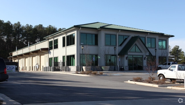
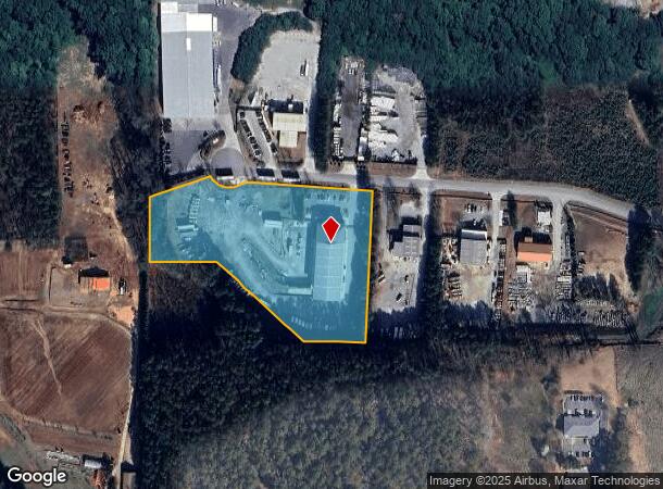
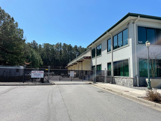
5665 Shirlee Industrial Way N, Alpharetta, GA 30004

NEARBY LISTINGS FOR SALE OR LEASE
Property Detail
5665 Shirlee Industrial Way N
Atlanta-Sandy Springs-Roswell, GA
Ind Park
018-140
2-1 541 LT5-6 SOUTH FORSYTH IND PARK
Industrialgeneral
Forsyth
X
Georgia
13121C0019G
5
2024
5.30 AC
2025
N Fulton/Forsyth Cnty
130601
Atlanta
35,072 SF
DEMOGRAPHICS near 5665 Shirlee Industrial Way N
1 Mile
3 Mile
5 Mile
2024 Total Population
3,206
39,290
114,626
2029 Population
3,473
43,817
126,662
Pop Growth 2024-2029
+ 8.33%
+ 11.52%
+ 10.50%
Average Age
38
37
38
2024 Total Households
1,011
12,984
39,428
HH Growth 2024-2029
+ 8.90%
+ 11.51%
+ 10.38%
Median Household Inc
$172,109
$134,976
$137,466
Avg Household Size
3.10
3.00
2.90
2024 Avg HH Vehicles
2.00
2.00
2.00
Median Home Value
$684,375
$479,422
$498,072
Median Year Built
2000
2002
2002
Nearby Places
Map Layers
Map Styles
 Street
 Aerial
- Restaurants
- Banks
- Shops
- Fitness
- Groceries
PUBLIC TRANSPORTATION
AIRPORT
Hartsfield - Jackson Atlanta International
DRIVE
WALK
Distance
Hartsfield - Jackson Atlanta International
59 min
42.5 mi
SALE & LEASE HISTORY
LISTING DATE
SALE/LEASE

Apr 10, 2022
For Sale
Nearby Properties
Address
Land Use
TOTAL SIZE
Lot Size
Zoning
Address
Land Use
TOTAL SIZE
Lot Size
Zoning
328,265 SF
4 AC
MP
Address
Land Use
TOTAL SIZE
Lot Size
Zoning
3,966,282 SF
25.68 AC
R4
Address
Land Use
TOTAL SIZE
Lot Size
Zoning
56,313 SF
13.37 AC
MP
Address
Land Use
TOTAL SIZE
Lot Size
Zoning
10,908 SF
107.57 AC
RES3
Address
Land Use
TOTAL SIZE
Lot Size
Zoning
90,671 SF
11.03 AC
MP
Address
Land Use
TOTAL SIZE
Lot Size
Zoning
119,926 SF
23.23 AC
M1
Address
Land Use
TOTAL SIZE
Lot Size
Zoning
64.48 AC
AG1
Address
Land Use
TOTAL SIZE
Lot Size
Zoning
83,161 SF
277.43 AC
A1
Address
Land Use
TOTAL SIZE
Lot Size
Zoning
207,663 SF
60.62 AC
R2R
Address
Land Use
TOTAL SIZE
Lot Size
Zoning
96,999 SF
10.93 AC
CBD
Address
Land Use
TOTAL SIZE
Lot Size
Zoning
293,211 SF
16.18 AC
M1
Address
Land Use
TOTAL SIZE
Lot Size
Zoning
130,155 SF
17.10 AC
M1
Address
Land Use
TOTAL SIZE
Lot Size
Zoning
91,585 SF
8.77 AC
C1
Address
Land Use
TOTAL SIZE
Lot Size
Zoning
198,235 SF
14.60 AC
M1
Address
Land Use
TOTAL SIZE
Lot Size
Zoning
95,950 SF
14 AC
M1
Address
Land Use
TOTAL SIZE
Lot Size
Zoning
73,120 SF
1.22 AC
AG1
Address
Land Use
TOTAL SIZE
Lot Size
Zoning
6.07 AC
MP
Address
Land Use
TOTAL SIZE
Lot Size
Zoning
6.97 AC
M1
Address
Land Use
TOTAL SIZE
Lot Size
Zoning
121,176 SF
5.86 AC
M1
Address
Land Use
TOTAL SIZE
Lot Size
Zoning
111,102 SF
9.06 AC
M1
Address
Land Use
TOTAL SIZE
Lot Size
Zoning
138,941 SF
26.40 AC
RES3
Address
Land Use
TOTAL SIZE
Lot Size
Zoning
112,810 SF
12.41 AC
M1
Address
Land Use
TOTAL SIZE
Lot Size
Zoning
82,035 SF
12.32 AC
C1
Address
Land Use
TOTAL SIZE
Lot Size
Zoning
151,980 SF
8.77 AC
M1
Address
Land Use
TOTAL SIZE
Lot Size
Zoning
6,298 SF
87.14 AC
A1
Address
Land Use
TOTAL SIZE
Lot Size
Zoning
124,700 SF
9.67 AC
M1
Address
Land Use
TOTAL SIZE
Lot Size
Zoning
181,540 SF
9.62 AC
M1
Address
Land Use
TOTAL SIZE
Lot Size
Zoning
4,800 SF
28.71 AC
M1
Address
Land Use
TOTAL SIZE
Lot Size
Zoning
217,056 SF
24.55 AC
CBD
Address
Land Use
TOTAL SIZE
Lot Size
Zoning
97,820 SF
8.39 AC
M1
The World's #1 Commercial Real Estate Marketplace
Connect with us
© 2025 CoStar Group
The information above has been obtained from sources believed reliable. While we do not doubt its accuracy we have not verified it and make no guarantee, warranty or representation about it. It is your responsibility to independently confirm its accuracy and completeness. Any projections, opinions, assumptions, or estimates used are for example only and do not represent the current or future performance of the property. The value of this transaction to you depends on tax and other factors which should be evaluated by your tax, financial, and legal advisors. You and your advisors should conduct a careful, independent investigation of the property to determine to your satisfaction the suitability of the property for your needs.